Not Shackled by a Bridge
The Amazon is one of the biggest rivers on Earth, and nobody has ever built a bridge across it.
The Amazon is one of the longest rivers in the world. Depending on how you measure it, it runs somewhere between 6,400 and 7,000 kilometres, from the Andes mountains in Peru all the way east to the Atlantic coast of Brazil. It carries more water than the next seven largest rivers in the world put together, about a fifth of all the fresh water that flows into the oceans. And yet, along that entire length, there is not a single bridge that crosses it.
Why not just build one?
My first thought was that it must simply be too wide. For most of its length, the river is a few kilometres across, widening to 10 kilometres or more near its lower reaches. That is wide, but humans have built far longer bridges. India’s Bogibeel Bridge over the Brahmaputra, a river famous for flooding and shifting its course, is almost 5 kilometres long and carries both trains and cars. The Congo, another enormous, wild river, has had the Matadi Bridge across it since 1983. Even India floods badly every single year, and we still build bridges over our rivers. So width is not the problem.
Walter Kaufmann, a structural engineer at ETH Zurich, points to two problems. Few places along the river need a bridge. For most of its length, the Amazon runs through dense rainforest with very few people and very few roads. A bridge is only useful if there is a road on both ends, and along most of the Amazon there simply is not. Where people do need to cross, they use boats and ferries, which have been moving people and goods up and down the river for centuries.
Flooding makes bridge foundations difficult to build. Every year, the river rises by more than 9 metres in the rainy season and spills into the forest around it. In the wet season, the flooded area grows from about 110,000 square kilometres to about 350,000, roughly the size of Germany. The banks are soft, muddy and constantly being reshaped by the water. A bridge needs solid ground to stand on, and the Amazon keeps moving the ground.
There is even a second, hidden “river” under the ground. In 2011, a team led by Valiya Hamza, an Indian-born geophysicist at Brazil’s National Observatory, announced that they had found another “river” flowing under the Amazon, about 4 kilometres underground. They worked it out from temperature measurements in 241 old oil wells, which suggested water was slowly moving through the rock deep below the surface. It runs about 6,000 kilometres, roughly following the Amazon from west to east, and is 200 to 400 kilometres wide.
It is not a river in the way we usually picture one, though. It is water seeping through porous rock, moving at less than a millimetre per second, slower than most glaciers. The Amazon above it moves at around 2 metres per second. Hamza himself said he used the word river “not in the conventional sense”, and many scientists think it should not be called a river at all. So does a second river underneath make the ground even shakier for a bridge? Probably not. At 4 kilometres deep, it is far below where any bridge foundation would reach. The ground problems engineers worry about are the ones at the surface, the floods, the mud and the moving banks.
Getting to Manaus
A crossing might make more sense at Manaus, the biggest concentration of people anywhere along the Amazon. It began in 1669 as a Portuguese fort at a river junction, became one of the richest cities in South America during the rubber boom of the late 1800s, and then boomed again after 1967, when Brazil turned it into a tax-free industrial zone and factories moved in. Today it is home to about 2.3 million people, all in one place surrounded by forest.
There is still no paved road connecting Manaus to the rest of Brazil. One highway runs north to Venezuela, and the one heading south towards Porto Velho starts with a ferry across the river and turns into an unusable dirt track after about 100 kilometres. Most people and goods come by boat or plane.
Manaus does have one big bridge, and that comes down to where the city was built in the first place. The old fort was not placed on the main Amazon but on the bank of the Rio Negro, its biggest tributary, just before the two rivers meet. So in 2011, when Brazil finally built the Rio Negro Bridge, a 3.6 kilometre cable-stayed bridge to the town of Iranduba, it crossed the Rio Negro, not the Amazon itself. To reach the highway on the south side of the main river, you still need a ferry.
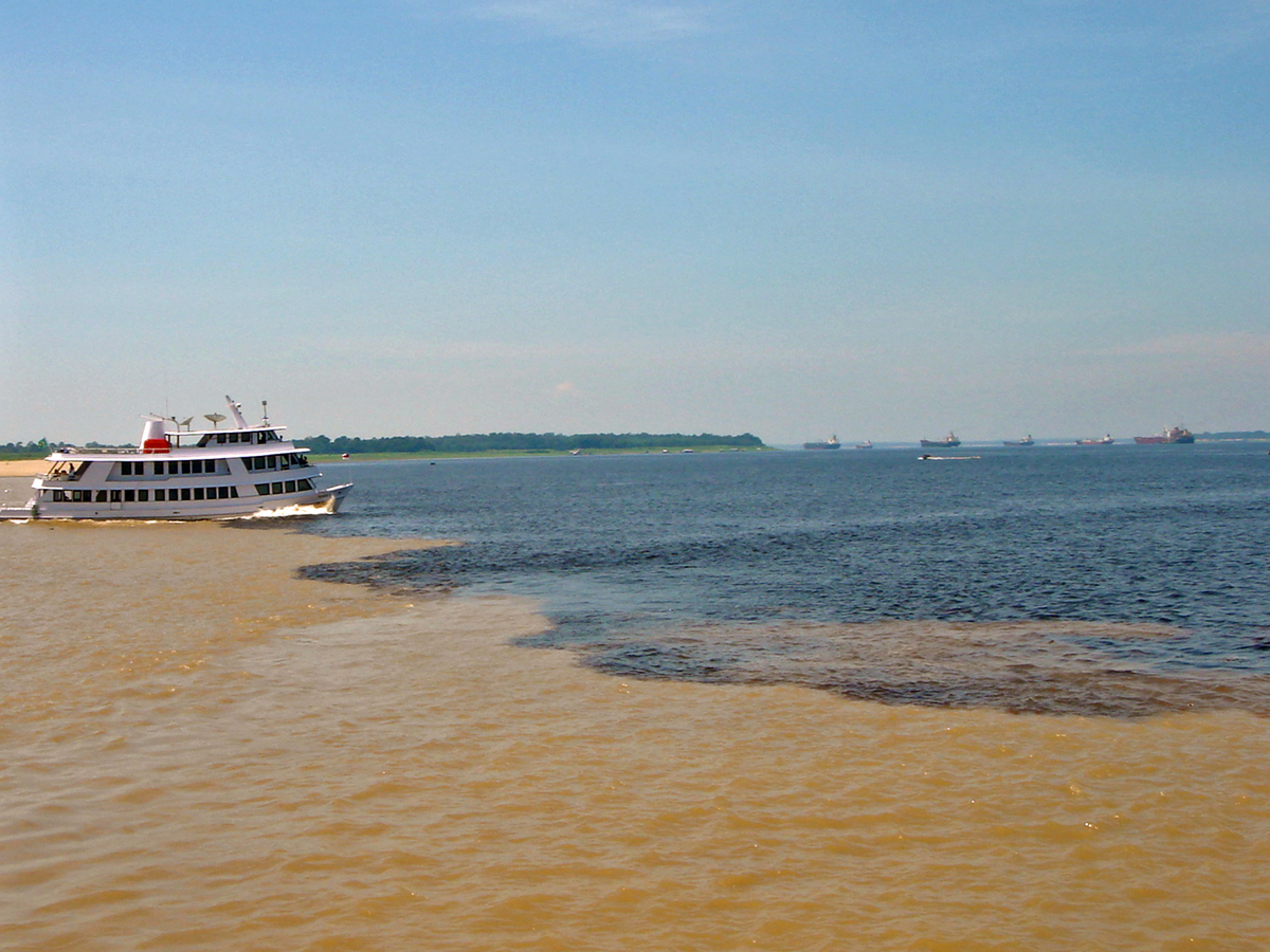
The Rio Negro is dark, almost black, because it carries dissolved material from decaying plants in the forest. The upper Amazon, which Brazilians call the Solimões, is pale and sandy, full of sediment from the Andes. They flow side by side for kilometres without mixing, because they differ in temperature, speed and density, so you can see a sharp line down the middle of the water. Locals call it the Meeting of Waters.